How do you read airspace on a sectional chart?
Each airspace class has its own line style in the FAA chart legend. Class B airspace is drawn with solid blue lines. Class C uses solid magenta lines. Class D uses dashed blue lines, and a Class E surface area uses dashed magenta lines.
Class E airspace that starts above the ground is shown with shaded bands. A magenta shaded band (vignette) marks Class E starting at 700 feet AGL. A blue shaded band marks Class E starting at 1,200 feet AGL.
How do you read altitudes on a sectional chart?
Class B and Class C altitude labels show the ceiling over the floor in hundreds of feet MSL. For example, 41 over 13 means the airspace runs from 1,300 feet MSL up to 4,100 feet MSL. The Class D ceiling is a number in a dashed box, also in hundreds of feet MSL. A minus sign in front means up to but not including that altitude.
Obstacles have two numbers. The upper number is the height of the top in feet MSL, and the number in parentheses is the height above ground (AGL). Many test questions hinge on picking the right one. The maximum elevation figure (MEF) in each grid quadrant is shown in thousands (large digit) and hundreds (small digit) of feet MSL.
What do airport symbols and data blocks mean?
An airport data block summarizes key information. In the example 1424 L 36, the field elevation is 1,424 feet MSL, L means runway lighting, and 36 means the longest runway is 3,600 feet.
A C in a magenta circle marks the CTAF frequency. A star above an airport symbol means a rotating beacon operating from sunset to sunrise.
What are military training routes on the chart?
Military training routes are labeled IR or VR. A four-digit route number means the route is at or below 1,500 feet AGL. A three-digit number means the route has segments above 1,500 feet AGL. Drone pilots should know where these routes are, because military aircraft may fly them at low altitude.
When do you need ATC authorization?
Controlled airspace, meaning Class B, C, D and Class E surface areas, requires ATC authorization under 14 CFR 107.41. Our LAANC guide explains how that works. Authorization is usually obtained through LAANC. On the test, a typical question shows a location on a chart and asks what you must do before flying there, so recognizing the airspace class is the key skill.
The chart excerpts you see on the test come from the FAA testing supplement, FAA-CT-8080-2H. Study with the same booklet so the symbols look familiar on test day.
How should you practice sectional chart questions?
Work slowly at first. For each question, find the location on the chart, identify the airspace and any labels around it, and only then read the options. Zoom in on small text instead of guessing. The practice below uses the 13 official FAA sample questions that include a figure. Tap a chart to open it full screen and zoom in.
Chart questions reward repetition. The more real excerpts you read, the faster you recognize line styles and labels.
Practice 13 FAA chart questions
Choose how to practice
Questions and figures: FAA Remote Pilot (UAG) sample questions, a public domain work of the U.S. Government. The FAA does not publish an answer key; answers and explanations are provided by Part 107 Prep and are not official. Part 107 Prep is not affiliated with the FAA or PSI.
All 13 chart questions with answers
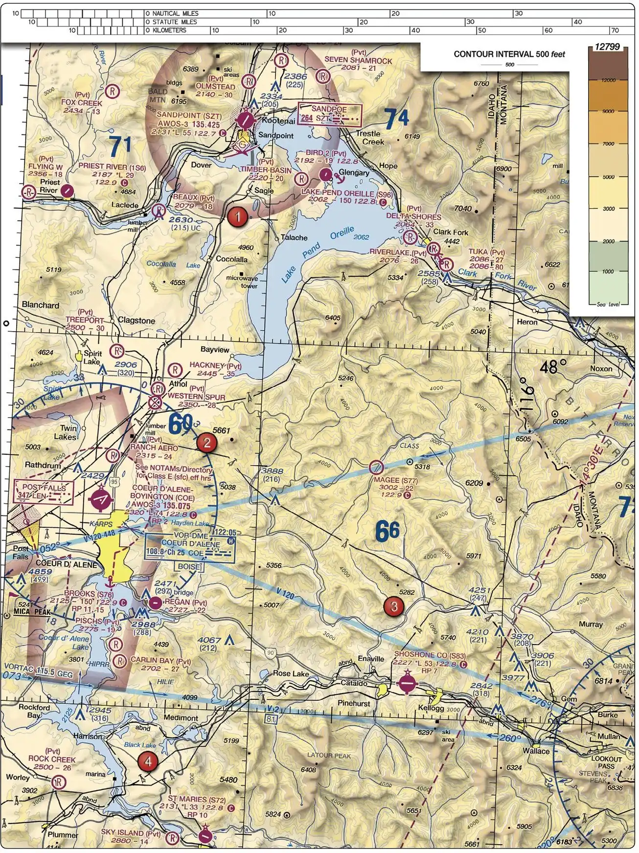
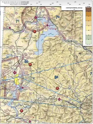
5. (Refer to Figure 22, area 2.) At Coeur D'Alene which frequency should be used as a Common Traffic Advisory Frequency (CTAF) to monitor airport traffic?
- A. 122.05 MHz.
- B. 135.075 MHz.
- C. 122.8 MHz.
Show answer
Correct answer: C. 122.8 MHz.
The CTAF is marked on the chart with a magenta letter C right after the frequency: at Coeur d'Alene that is 122.8. The other numbers in the airport data block are traps: 135.075 is the AWOS weather broadcast, 122.05 belongs to Flight Service. Monitoring the CTAF tells you where manned traffic is in the pattern.
ACS code: UA.V.B.K6a
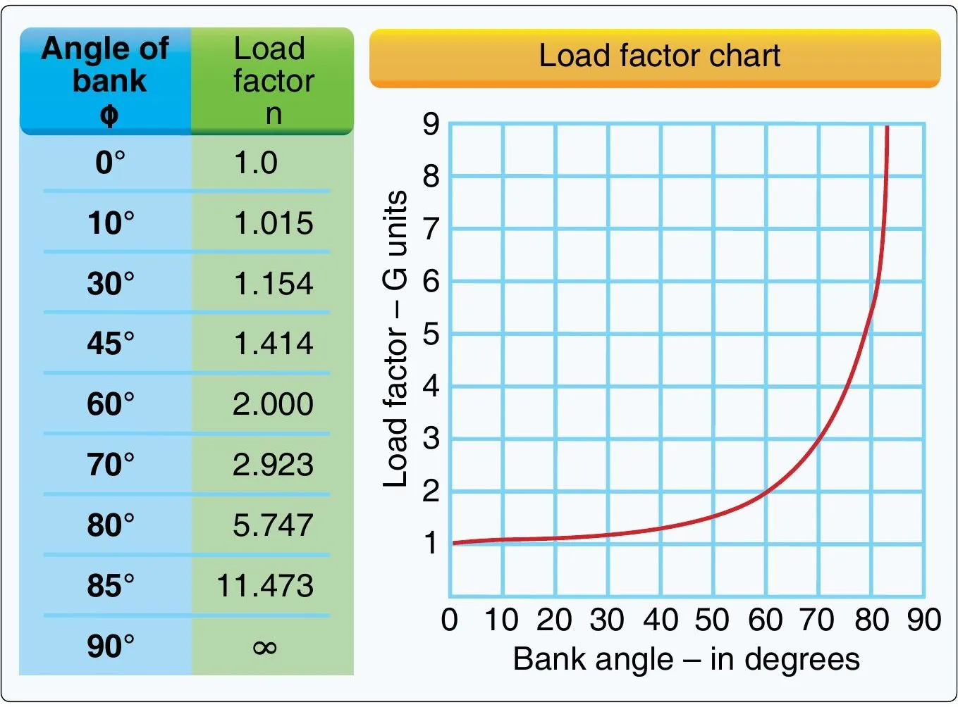
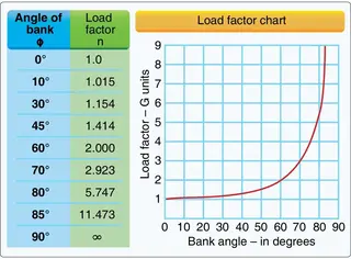
7. (Refer to Figure 2.) If an unmanned airplane weighs 33 pounds, what approximate weight would the airplane structure be required to support during a 30° banked turn while maintaining altitude?
- A. 47 pounds.
- B. 38 pounds.
- C. 34 pounds.
Show answer
Correct answer: B. 38 pounds.
The load factor chart shows about 1.154 G for a level 30° bank. 33 lb × 1.154 ≈ 38 lb. The physics: in a bank, lift must both hold the aircraft up and pull it around the turn, so the structure carries more than the aircraft's weight. At 60° bank the factor reaches 2 G: double the weight, and a favorite exam variation.
ACS code: UA.IV.A.K1a
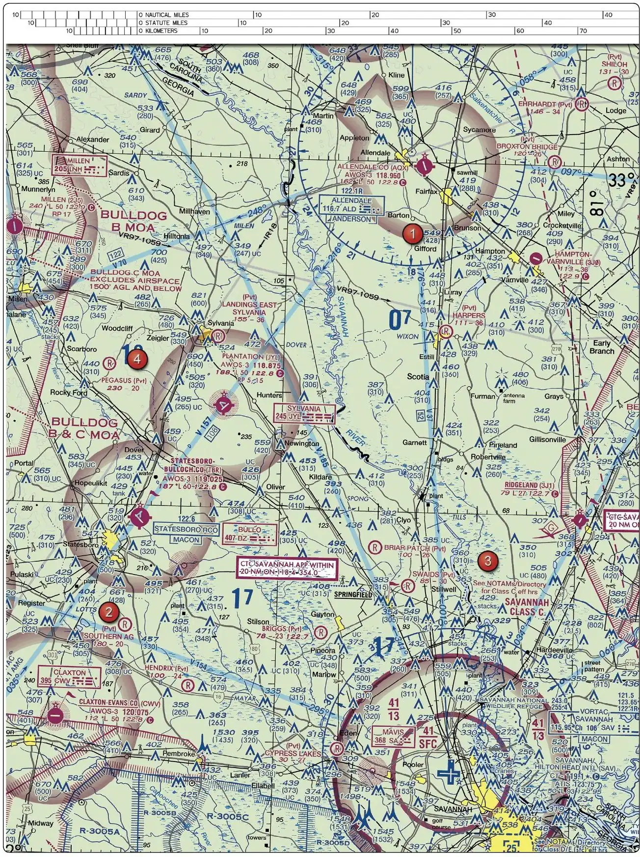
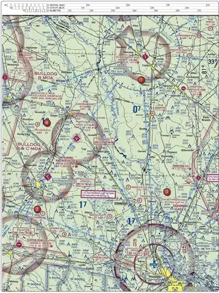
8. (Refer to Figure 23, area 3.) What is the floor of the Savannah Class C airspace at the shelf area (outer circle)?
- A. 1,700 feet MSL.
- B. 1,300 feet AGL.
- C. 1,300 feet MSL.
Show answer
Correct answer: C. 1,300 feet MSL.
Class C shelves are labeled like a fraction: 41/13 means ceiling 4,100 ft MSL over a floor of 1,300 ft MSL. Sectional chart altitudes are MSL unless explicitly marked AGL: that single letter is what this question is really testing. Under the shelf you are still inside the lateral boundary but below the floor, so that airspace is not Class C, and LAANC grids may still apply nearby.
ACS code: UA.II.A.K1b
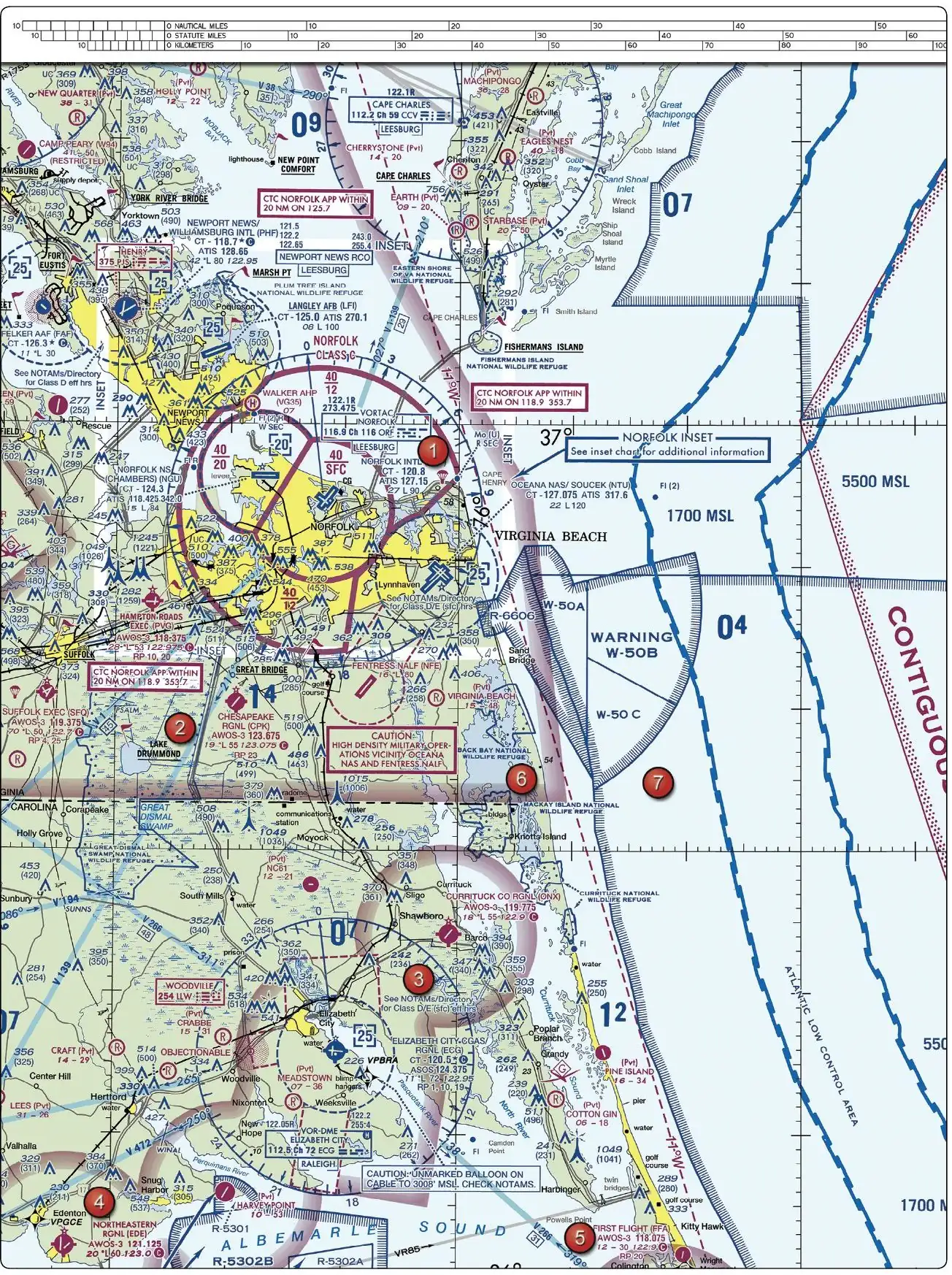
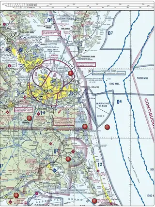
9. (Refer to Figure 20, area 3.) With ATC authorization, you are operating your small unmanned aircraft approximately 4 SM southeast of Elizabeth City Regional Airport (ECG). What hazard is indicated to be in that area?
- A. High density military operations in the vicinity.
- B. Unmarked balloon on a cable up to 3,008 feet MSL.
- C. Unmarked balloon on a cable up to 3,008 feet AGL.
Show answer
Correct answer: B. Unmarked balloon on a cable up to 3,008 feet MSL.
The CAUTION box near Elizabeth City warns of an unmarked balloon on a cable to 3,008 ft, and like all charted altitudes, that number is MSL unless expressly labeled AGL. The MSL/AGL distinction is the whole question; the tethered cable is nearly invisible and would destroy a drone instantly, which is why the chart shouts about it.
ACS code: UA.V.B.K6a
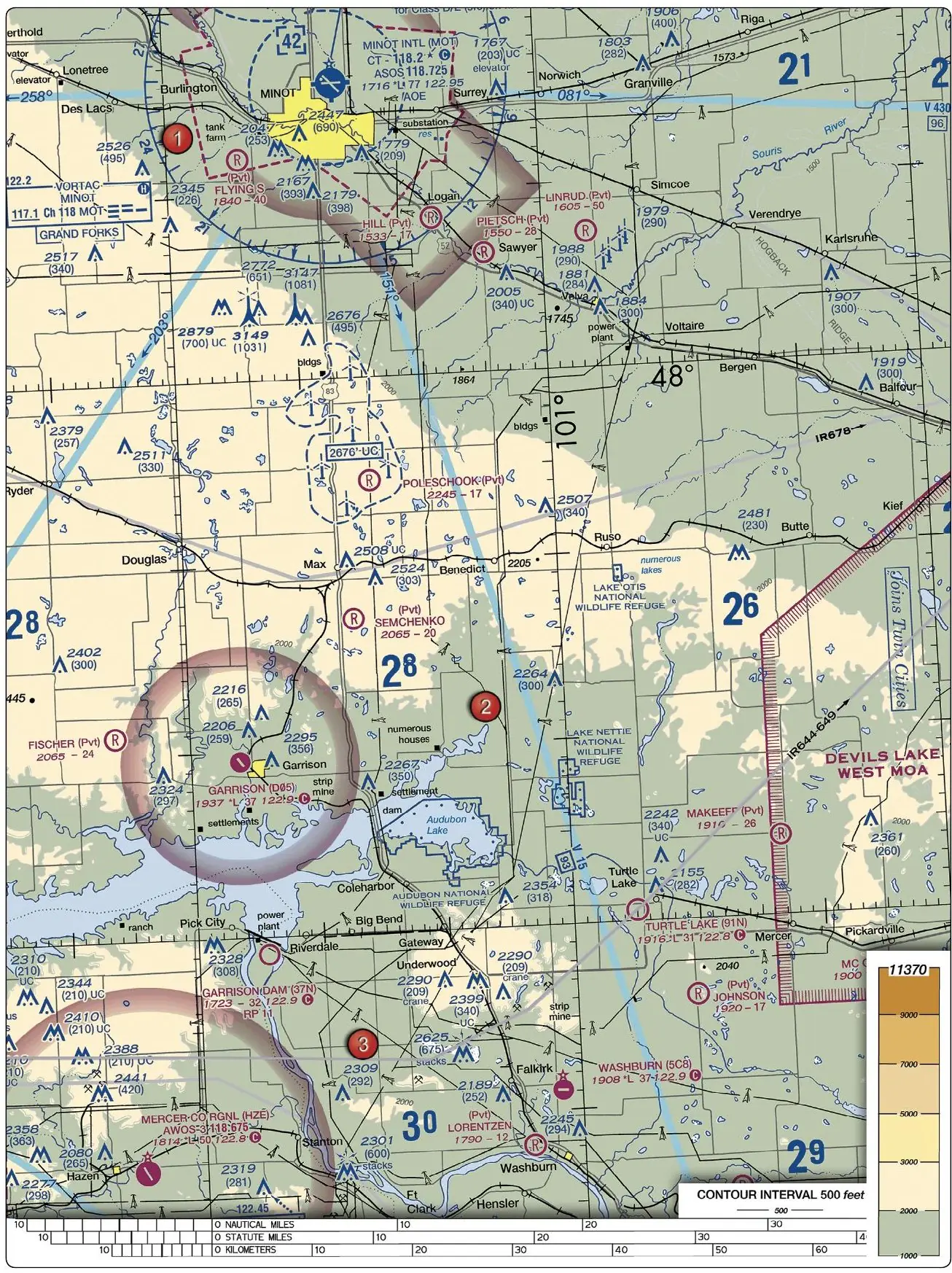
10. (Refer to Figure 21.) You have been hired by a farmer to use your small UA to inspect his crops. The area that you are to survey is in the Devil's Lake West MOA, east of area 2. How would you find out if the MOA is active?
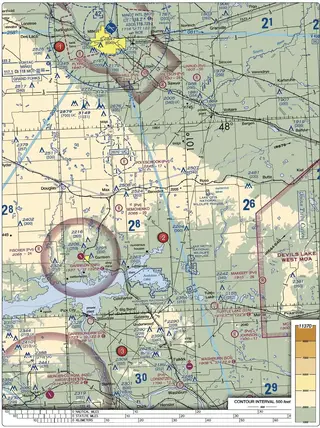
- A. This information is available in the Small UAS database.
- B. Refer to the Military Operations Directory.
- C. Refer to the chart legend.
Show answer
Correct answer: C. Refer to the chart legend.
Every sectional chart carries a tabulation of its special use airspace: name, altitudes, times of use and controlling agency. That panel is part of the chart legend, which is why the legend is the correct place to start. A 'Small UAS database' and a 'Military Operations Directory' do not exist; for real-time status you would additionally check NOTAMs or contact the controlling agency.
ACS code: UA.II.A.K2
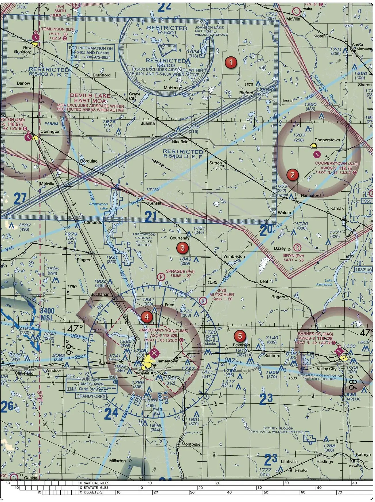
13. (Refer to Figure 26, area 4.) You have been hired to inspect the tower under construction at 46.9N and 98.6W, near Jamestown Regional (JMS). What must you receive prior to flying your unmanned aircraft in this area?
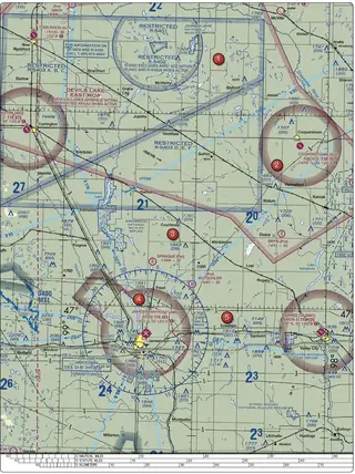
- A. Authorization from the National Park Service.
- B. Authorization from the military.
- C. Authorization from ATC.
Show answer
Correct answer: C. Authorization from ATC.
The dashed magenta line around Jamestown Regional marks Class E surface airspace, controlled airspace beginning at the ground. Under § 107.41 that requires prior ATC authorization just like Class D. The tower's location inside that boundary is what the coordinates lead you to discover; neither the military nor the Park Service controls this airspace.
ACS code: UA.V.B.K6a
14. (Refer to Figure 20, area 5.) How would a remote PIC "CHECK NOTAMS" as noted in the CAUTION box regarding the unmarked balloon?
- A. By utilizing the B4UFLY mobile application.
- B. By obtaining a briefing via an online source such as: 1800WXBrief.com.
- C. By contacting the FAA district office.
Show answer
Correct answer: B. By obtaining a briefing via an online source such as: 1800WXBrief.com.
NOTAMs are distributed through the Flight Service briefing system: online at 1800WXBrief.com (or by phone at 1-800-WX-BRIEF). B4UFLY shows airspace, not the full NOTAM picture, and the local FSDO is not a briefing facility. When a chart tells you to 'check NOTAMs', it means: get a briefing before you fly.
ACS code: UA.II.B.K5
18. (Refer to Figure 26, area 2.) While monitoring the Cooperstown CTAF you hear an aircraft announce that they are midfield left downwind to RWY 13. Where would the aircraft be relative to the runway?
- A. The aircraft is West.
- B. The aircraft is East.
- C. The aircraft is South.
Show answer
Correct answer: B. The aircraft is East.
Work it in three steps: runway 13 points to about 130° (southeast). Downwind is flown opposite, heading about 310°. In a LEFT pattern the runway lies off the pilot's left side, which places the downwind leg northeast of the field: East among the choices. Being able to place pattern traffic from radio calls is exactly the skill this tests.
ACS code: UA.V.A.K3
24. (Refer to Figure 21.) What airport is located approximately 47 (degrees) 40 (minutes) N latitude and 101 (degrees) 26 (minutes) W longitude?
- A. Garrison Airport.
- B. Semshenko Airport.
- C. Mercer County Regional Airport.
Show answer
Correct answer: A. Garrison Airport.
Latitude lines run horizontally (47°40'N sits two-thirds of the way from 47° toward 48°), longitude lines vertically (101°26'W is about halfway between 101° and 102°, remembering longitude increases westward). The intersection lands on Garrison. Each printed tick is one minute; count carefully, Mercer County sits noticeably south.
ACS code: UA.V.B.K6a
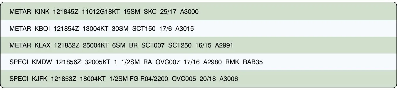
25. (Refer to Figure 12.) What are the current conditions for Chicago Midway Airport (KMDW)?
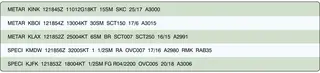
- A. Sky 7,000 feet overcast, visibility 1-1/2SM, heavy rain.
- B. Sky 700 feet overcast, visibility 11, occasionally 2SM, with rain.
- C. Sky 700 feet overcast, visibility 1-1/2SM, rain.
Show answer
Correct answer: C. Sky 700 feet overcast, visibility 1-1/2SM, rain.
Decode the METAR piece by piece: OVC007 = overcast at 700 ft (cloud heights are in hundreds of feet), 1 1/2SM = visibility one and a half statute miles, -RA = light rain (the minus sign means light, a plus would mean heavy). The classic traps are misreading 007 as 7,000 ft and ignoring the intensity prefix.
ACS code: UA.III.A.K2
26. (Refer to Figure 12.) The wind direction and velocity at KJFK is from
- A. 180° true at 4 knots.
- B. 180° magnetic at 4 knots.
- C. 040° true at 18 knots.
Show answer
Correct answer: A. 180° true at 4 knots.
18004KT reads as: wind FROM 180° at 4 knots. Written METAR winds are always TRUE north references: only winds spoken over the radio (ATIS, tower) are magnetic. Remember: 'if you read it, it's true; if you hear it, it's magnetic.'
ACS code: UA.III.A.K2
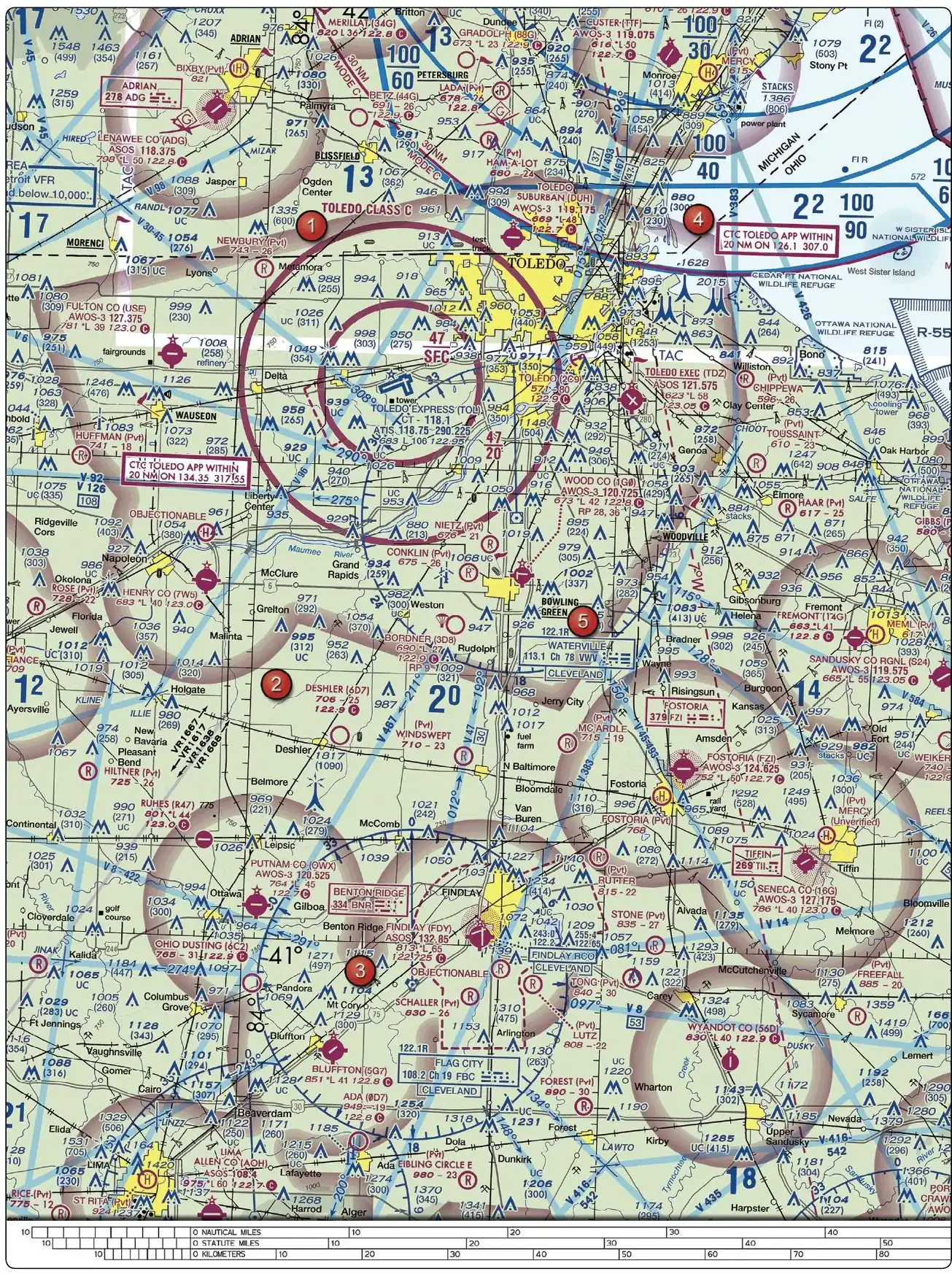
30. (Refer to Figure 59, area 2.) The chart shows a gray line with "VR1667, VR1617, VR1638, and VR1668." Could this area present a hazard to the operations of a small UA?
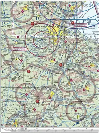
- A. Yes, the defined route provides traffic separation to manned aircraft.
- B. Yes, this is a Military Training Route from the surface to 1,500 feet AGL.
- C. No, all operations will be above 400 feet.
Show answer
Correct answer: B. Yes, this is a Military Training Route from the surface to 1,500 feet AGL.
Military Training Route numbering encodes altitude: four digits (VR1667) mean the route has no segment above 1,500 ft AGL, exactly where your drone flies; three digits would mean segments above 1,500 ft. VR routes are flown fast (over 250 knots) and low, so they absolutely matter to sUAS. MTRs provide no separation service.
ACS code: UA.II.A.K2
31. (Refer to Figure 26.) What does the line of latitude at area 4 measure?
- A. The degrees of latitude east and west of the line that passes through Greenwich, England.
- B. The degrees of latitude east and west of the Prime Meridian.
- C. The degrees of latitude north and south of the equator.
Show answer
Correct answer: C. The degrees of latitude north and south of the equator.
Latitude measures north-south from the equator (0°) to the poles (90°); longitude measures east-west from the Prime Meridian through Greenwich. Both wrong answers describe longitude. Memory hook: latitude lines look like the rungs of a LADDER lying flat, 'ladder-tude'.
ACS code: UA.V.B.K6a